Trail Running at the Krk Island Trail
Stage 01
from Stara Baška to Baška
Warming up over the Karst mountains between the two beautiful places in the south of the island of Krk
After breakfast you will take a shuttle from your accommodation in Krk to Stara Baška. There your trail run begins. In Stara Baška you run through the village back in the direction from which you came. When you reach the main road, walk about 100 meters in the direction of Krk and then turn right onto the marked trail that will take you inland. Follow this path until you reach the saddle “Vratudih” between the peaks Veliki Hlam and Vrska Glava at about 350 m above sea level. At the signpost in the saddle, turn right (southeast) and walk along the ridge over Vrska Glava (390 m) and on the other side over the ridge downhill until you reach a saddle at 180 m above sea level – on this path you always have your destination Baška in sight and until you reach the saddle you actually pass Baška. In the saddle you turn sharply to the left (north) and reach the old town of Baška, your destination today, via a marked path running downhill, first the new part of Baška and then always along the coast (once going around a campsite on the left).
Lenght: 11,0 km
Ascent: 385 m
Descent: 386 m
")
Trail Running at the KrK Island Trail © www.trailrunning-szene.at
Stage 02
from Baška to Vrbnik
The royal stage over the so-called “Moon Plain”, a very lonely karst mountain range, and later through oak forests
In Baška north through the village, cross the main road and up the small road in hairpin bends to Kastel Baška.
You continue to run on a very beautiful old cart path with magnificent views back to Baška through pine forest uphill.
At a crossroads you keep left and shortly thereafter leave the forest. Again shortly thereafter right until you reach a gravel road. This you run left along.
At a crossroads you leave the good gravel road and choose the worse gravel road on the right. You now always follow the yellow markings:
The road soon stops and becomes a path. Continue along this path, through a ditch and always uphill until you reach a striking large water basin interspersed with dry stone walls. Here you follow the left dry stone wall (on its right side) and walk along it without markings, first level, then after a left turn slightly downhill to a gravel road. Follow this to the right until after a while you turn right at a fork in the road (difficult to see, see GPS track). This weakly marked path you run to a blue gate (Ww. “Kota 387”).
You run right through this and follow the path through old oak forests and along overgrown dry stone walls – always following the weak markings – until you leave the forest through a gate again. Now without a trail or following the faint tracks and looking for the markings, first cross the slope a bit and later pleasantly downhill through a very beautiful heath landscape. The further down you go, the better the path becomes and the more wooded the surroundings. Follow the path until you reach a crossroads. To the right you can make a short detour to a nearby secluded beach, but our actual path leads to the left. Follow the path until you reach a larger beach with a parking lot. Now follow the small asphalt road until another small asphalt road branches off to the right. Follow it to the right until you reach the center of Vrbnik.
Lenght: 23,3 km
Ascent: 679 m
Descent: 670 m
Stage 03
from Vrbnik to Krk
First along the coast then through beautiful forests through the interior of the island to Krk
In Vrbnik, you first walk along the main road until you cross the depression via a small road and then always follow the markings on small asphalt roads out of Vrbnik. Continue to follow the markings of this small road above the coast until the road descends to the coast and changes to a gravel surface. Now still follow this road until at a cove links a gravel road leads inland (markings). Follow this gravel road (or shortcuts) until you reach the small village of Risika and a larger asphalt road. Follow this road for about 150 m to the left and then turn right into a small asphalt road. Follow this road through the hamlet of Paprata until you reach a fenced building. Behind this building, turn right on an asphalt road through a valley and continue until you reach a larger road (ignore a fork on the right). Follow this road until you turn left at some buildings. Shortly you will reach a big road. Cross this road and follow the marked trail for a while until you reach another asphalt road. Turn right into this road and you will soon reach a crossroads near the village of Kampelje. Turn diagonally right here and after about 200 m in a right-hand bend turn straight ahead onto a hiking trail. Follow the marked path until you reach the village of Kornić. Go through the village and turn right at the end of the village. Now follow the markings along the outskirts of the village and later turn left more or less at the same level through olive groves until you reach the crossroads with bike path no. 8. Here you turn right and walk slightly uphill to the next fork. There you continue to the left until you reach the bypass road of Krk. Cross the road and take the path on the opposite side, which will soon take you to the first houses of Krk. You follow the streets of Krk towards the sea and reach the already visible old town of Krk and thus the well-deserved destination of your trail run. Here you can celebrate your success in the stylish ambience of the old town of Krk by the sea and review the last eventful days.
Lenght: 22,0 km
Ascent: 414 m
Descent: 441 m

Passing beautiful bays, beaches and wild mountains © www.trailrunning-szene.at
Equipment:
Each participant must be equipped with:
• Trail running shoes with profiled sole suitable for running in alpine terrain
• Overgarment for protection against rain (waterproof rain jacket min. 10.000ml water column)
• Warm clothing (top and long trousers or leg warmers) as an insulating intermediate layer under the overgarments (for bad weather, which can start surprisingly in high mountains). As a basic rule, no skin should be visible!
• A shirt to change
• Gloves and cap
• Water container with a capacity of at least 1,5l
• Refreshment (gel, bars, snacks)
• Identity card in a waterproof cover
• Emergency equipment (1 rescue blanket, 1 compress 10×10, 2 bandage packs, 2 gloves, 4 plasters, emergency whistle, blister plaster)
• Running backpack
• Fully charged mobile phone
• Headlamp with additional batteries
We also recommend carrying sunscreen, sports sunglasses, trail running poles, lotion to prevent rubbing wounds.
Author
Günter Mussnig
The graduate geographer is one of the founders and managing directors of Trail Angels, which is responsible for the Bookyourtrail.com web platform. As a trekking & outdoor enthusiast, he is one of the fathers of the Alpe-Adria Trail and has been exploring the Nepalese Himalayas for more than 25 years.

Related articles

Flying Without Wings
The title of Tiziano Terzani’s bestseller could not describe our appearance at this year’s ITB Berlin any better! As Trail Angels, we are skipping the fair this year due to a heavy workload—while several of our projects are celebrating their premiere at the...
Iron Curtain Trail – EuroVelo 13
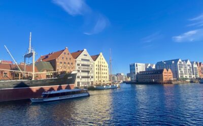
Gdansk, a pearl on the Baltic Sea, was the symbolic venue for the ICTr-CE project meeting. © Trail AngelsToday we report on the progress of a groundbreaking transnational Interreg project. The ICTr-CE project is dedicated to the further development of the Iron Curtain...
Get in touch
Every great journey begins with the first click.
If we could inspire you for responsible tourism, just get in touch with us. Who knows, maybe something big will come out of this first click!